Compact dual sensor 3D sidescan for side-mounted pole and small AUV applications.
3DSS-DX-450
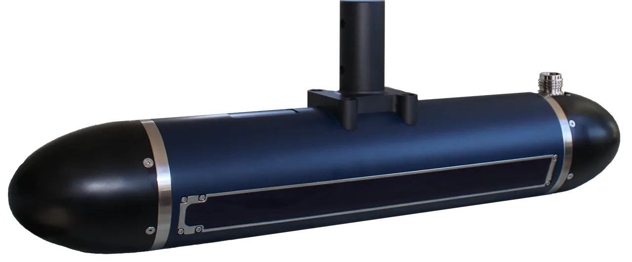
The 3DSS-DX utilizes state-of-the-art acoustic transducer array technology, SoftSonar™ electronics and advanced signal processing to produce superior bathymetry and 3D sidescan images. This patented technology is able to resolve multiple concurrent sound wave arrivals, separating backscatter from the seabed, sea surface, water column and multipath arrivals. The result is stunning 3D sidescan imagery across the water column and superior swath bathymetry from a compact, easy-to-use sonar.
Basic Specifications
Feature
- Proven bathymetric accuracy and repeatability ( exclusively available from IHO ).
- High-resolution true 3D graphics.
- Real-time 3D point cloud display and target capture software.
- Simultaneously output 3D sidescan, 2D sidescan and bathymetric data.
- Wide coverage, up to 14 times deeper water.
- Patented processing techniques and beamforming eliminate multipath and surface reflection interference.
- Support for 3rd party hydrographic hardware and software.
- Compact, low power consumption, and easy to use. Suitable for ASV and AUV applications.
Application
- Shallow water hydrographic survey
- Habitat mapping
- Shallow Water IED Minehunting ( MCM ) Detection
- Ports and port security
- Ocean Debris Search
- Subsea structure survey/inspection
- Dredging operations
- Underwater archaeology
- ASV and AUV Applications
- Tailing pond survey
Turnkey hydrographic survey solutions with integrated peripherals for sideroof mount and small AUV applications.
3DSS-iDX-450
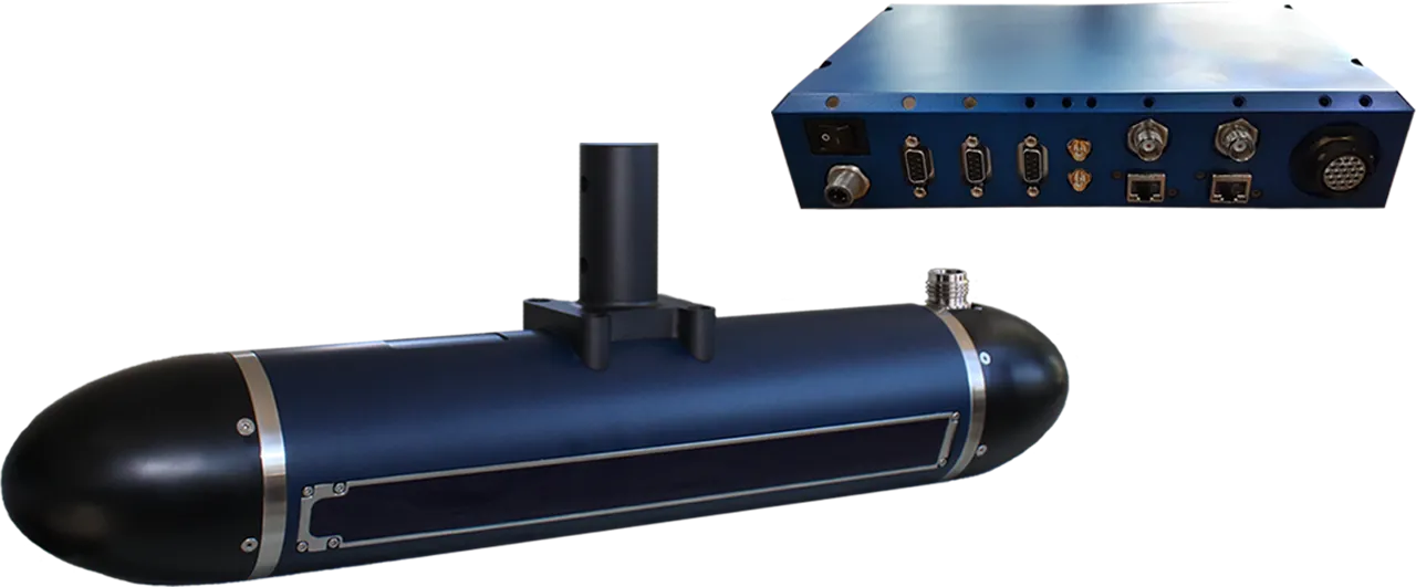
3DSS-iDX employs a patented signal processing approach that extends the single angle of arrival principle used in interferometric systems to accommodate multiple simultaneous backscatter arrivals ( e.g. seabed, sea surface, water column and multipath ). The result is superior wide-swath bathymetry and true 3D sidescan imaging in a compact, easy-to-use sonar. The iDX-450 integrates SVT and MRU sensors into the sonar head for turnkey operation. The Universal Sonar Interface Unit provides ultra-portable, simple operation with just a laptop and a battery, or simple interface to external MRU, GNSS and INS systems on a fully equipped survey launch or ASV.
Basic Specifications
Feature
- Fully integrated AML MicroX sound velocity sensor
- Fully integrated SBG Ellipse2-E with GNSS aiding
- Fully integrated or external GNSS
- Proven bathymetric accuracy and repeatability ( exclusive to IHO ).
- High-resolution true 3D graphics.
- Real-time 3D point cloud display and target capture software.
- Simultaneously output 3D sidescan, 2D sidescan and bathymetric data.
- Wide coverage, up to 14 times deeper water.
- Patented processing techniques and beamforming eliminate multipath and surface reflection interference.
- Support for 3rd party hydrographic hardware and software.
- Compact, low power consumption, and easy to use.
- Suitable for ASV and AUV applications.
Application
- Shallow water hydrographic survey
- Low Flow Hydrological Measurement
- Habitat mapping
- Shallow Water IED Minehunting ( MCM ) Detection
- Ports and port security
- Ocean Debris Search
- Subsea structure survey/inspection
- Dredging operations
- Underwater archaeology
- ASV and AUV Applications
- Tailing pond survey
The 3DSS-DX-450 AUV Integration Package is a flexible, compact dual sensor sonar package that can be configured to unmanned platforms requiring high resolution 3D imagery.
3DSS-DX-450-AUV
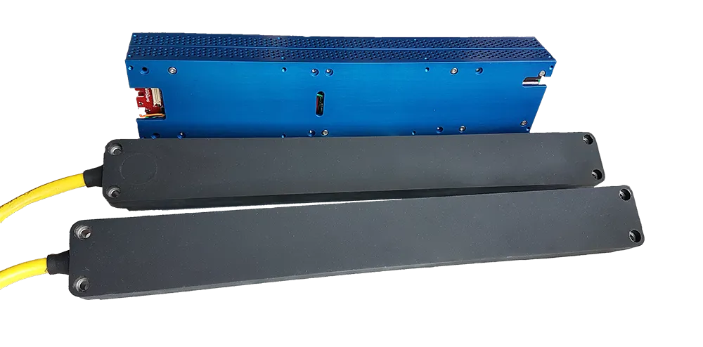
The 3DSS-DX-450-AUV employs a patented signal processing approach that extends the single angle of arrival principle used in interferometric systems to accommodate multiple simultaneous backscatter arrivals ( e.g. seabed, sea surface, water column and multipath ). The result is superior wide-swath bathymetry and true 3D sidescan imaging in a compact, easy-to-use sonar. The DX-450-AUV provides ultra-wide, multi-angle imaging for unmanned platforms. Low logistics operations and low power requirements make the 3DSS-DX-450 AUV package the perfect sonar to provide wide 3D imagery on unmanned platforms from the surf zone to 4 km below the surface.
Basic Specifications
Feature
- Compact, low power consumption, and easy to use.
- Suitable for ASV and AUV applications.
- 4000m depth rating.
- Simultaneously output 3D sidescan, 2D sidescan and bathymetric data.
- Proven bathymetric accuracy and repeatability ( exclusively available from IHO ).
- High-resolution true 3D graphics.
- Real-time 3D point cloud display and target capture software.
- Wide coverage, up to 14 times deeper water.
- Patented processing techniques and beamforming eliminate multipath and surface reflection interference.
- Support for 3rd party hydrographic hardware and software.
Application
- Autonomous hydrological survey
- Shallow Water IED Minehunting ( MCM ) Detection
- Ports and port security
- Ocean Debris Search
- Subsea structure survey/inspection
- Dredging operations
- Underwater archaeology
- Quick Assessment
- Tailing pond survey